William Montgomery's Land Grant Is Not Located inMontgomery County
by Kameron K. Searle William Montgomery's Mexican land grant is NOT located in present day Montgomery County, Texas. Any claims to the contrary are false. William Montgomery NEVER owned land or lived in what is today Montgomery County. Any claims to the contrary are ridiculous and misleading. We will look at the primary source evidence in detail. William Montgomery received a land grant from Stephen F. Austin in 1831 which is located entirely within Grimes County today. No part of the land grant is actually located in today's Montgomery County. As we will see, the eastern boundary line of William Montgomery's land grant actually forms part of the eastern boundary line of Grimes County. William Montgomery's sons, Andrew Montgomery, Edley Montgomery and John Montgomery, received no Mexican land grants in Montgomery County or Grimes County at all. The Republic of Texas land grants the sons received title to in 1841 are not located in present day Montgomery County, Texas either. These Republic of Texas land grants are located in the Plantersville and Stoneham areas of Grimes County today. See the articles Andrew Montgomery Never Received a Land Grant From Stephen F. Austin and Montgomery Brothers Were Latecomers. A webpage that repeatedly makes the claim that William Montgomery's land grant of 1831 extends into today's Montgomery County is titled Montgomery: Naming Questions. The quotes with the grey backgrounds and the maps identified as such below were accessed from the webpage http://www.texascenterforregionalstudies.net/montgomery.html on September 9, 2020. The webpage Montgomery: Naming Questions indicated that the information was submitted by Robin Navarro Montgomery and Joy Renee Montgomery.
Byline on the webpage Montgomery: Naming Questions.
William Montgomery's Mexican Land Grant Does Not Extend Into Present Day Montgomery County On the webpage, Montgomery: Naming Questions, assertions are repeatedly made to the effect that a portion of William Montgomery's land grant is somehow located in today's Montgomery County. We will look at each of these statements, compare them to primary source evidence (including maps, various land grants, surveyor field notes, surveyor plat and the Act Creating Grimes County) and observe how each of the statements is wrong. We will also look at a number of altered maps proferred by Robin and Joy Montgomery as alleged proof of their assertions. We will look at how each of these maps as altered is wrong with regard to William Montgomery's land grant. There are other problems with these maps, but we will stick to the subject of this webpage which is the fact that no part of the William Montgomery League is located in today's Montgomery County. In 1831, Stephen F. Austin granted a league of land (4,428.4 acres) to William Montgomery. At times, Robin and Joy Montgomery refer to the William Montgomery League as William Montgomery's survey, William Montgomery's land grant or William Montgomery's league on their webpage, Montgomery: Naming Questions. I will endeavor to refer to the Mexican land grant that William Montgomery received from Empresario Stephen F. Austin in 1831 as the William Montgomery League whenever possible in an effort to reduce any confusion. Here is the first example from the webpage Montgomery: Naming Questions and it references the map located below it. For the purpose of discussion, we will refer to this map as Robin and Joy Montgomery's Map #1.
Robin and Joy Montgomery's Map #1.
Early Primary Source: Grimes County Map
The statement, "Note the land to the east of William Montgomery's survey was also part of his original land grant," is not a true statement. As we saw in the articles Andrew Montgomery Never Received a Land Grant From Stephen F. Austin and Montgomery Brothers Were Latecomers, there are a number of things that are obviously wrong with Robin and Joy Montgomery's Map #1. On this webpage we will focus primarily on the errors and false statements associated with the William Montgomery League. Note the red rectangle drawn around what is purported to be William Montgomery's
survey by Robin and Joy Montgomery.
The first glaring error with the map as altered is that the red rectangle does not follow the actual shape of the William Montgomery League.
Traveling east to west across the northern boundary of the William Montgomery League, a portion of the red rectangle
heading towards the west has been incorrectly drawn into the John Landrum League to include several hundred acres that never
belonged to William Montogmery. The east side of Robin and Joy Montgomery's Map #1 is an even bigger
problem and is the subject of this webpage. Robin and Joy Montgomery have drawn the red rectangle past the eastern boundary
line of William Montgomery League so as to include more than 1,100 acres of land to the east of the William Montgomery League that
were NEVER surveyed for, granted to, or owned by William Montgomery.
Below is a scan of the original 1858 Grimes County map that Robin and Joy Montgomery used to produce
Robin and Joy Montgomery's Map #1. Here it is enlarged without any of Robin and Joy Montgomery's alterations to show the actual boundaries of William
Montgomery's 1831 Mexican land grant (William Montgomery League). The original 1858 map of Grimes County can be accessed on the
Texas General Land Office website at
https://s3.glo.texas.gov/glo/history/archives/map-store/index.cfm#item/3605. I encourage all readers to take a look at
the original map. By going to the Texas General Land Office website, it is easy to enlarge the map and look at all details
more closely. Please do not restrict yourself to the 1858 Grimes County map. You can use any legitimate map of Grimes County
since 1846 (the year the county was created). I am only using the 1858 Grimes County map here because that is the map Robin
and Joy Montgomery used to create theirs. I used it in order to compare apples to apples. Close Up of 1858 Map of Grimes County Above is a scan of the 1858 map of Grimes County that was used by Robin
and Joy Montgomery to prepare Robin and Joy Montgomery's Map #1 without all of their alterations and additions.
Note the thick grey line running north to
south through the Asa Yeamans League and the Jacob Shannon League down to the northeast corner of the William
Montgomery League. That is the Grimes County line separating Grimes County from Montgomery County.
The county line then runs south down the eastern boundary line of the William Montgomery League. You will
also notice that the William Montgomery League is located entirely to the west of the Grimes County line. No part of the
William Montgomery League crosses into present day Montgomery County, and it is totally incorrect to claim that it does. In the map below prepared by Searle, Grimes County and Montgomery County are designated on each
side of the county line which is indicated here with a black line. Close Up of 1858 Map of Grimes County Showing the County Line Note that the northeasternmost sliver of Asa Yeamans' League is located in
Montgomery County and the southwesternmost sliver of Jacob Shannon's League is located in Grimes County.
But all of William Montgomery's League is located entirely within Grimes County. The part of Robin and
Joy Montgomery's Map #1 that makes no sense at all is the part where they have drawn their red rectangle
onto the land east of the William Montgomery League. The lands to the east of the William Montgomery League as
shown on Robin and Joy Montgomery's Map #1 were never surveyed for, granted to or owned by William Montgomery. Below is the 1858 Grimes County Map in its entirety. It is shown here so that the
reader can see the location of the eastern Grimes County line separating Grimes County and Montgomery County. 1858 Map of Grimes County, Texas Earlier Primary Sources: An Act Creating Grimes County and the Original Land Owners Grimes County was created by the Texas State Legislature in 1846 from part of the territory of
Montgomery County. Below is a transcription of "An Act Creating Grimes County" from Early Laws of Texas: General Laws from 1836
to 1879, Compiled and Arranged by John Sayles and Henry Sayles (The Gilbert Book Co., St. Louis, 1891), page 30.
Note that the "league of land granted to W. Montgomery" is mentioned specifically in the act creating Grimes County. The eastern
boundary line of the William Montgomery League forms part of the eastern county line of Grimes County by statute. An Act Creating Grimes County In the map below prepared by Searle, the actual boundary lines of William
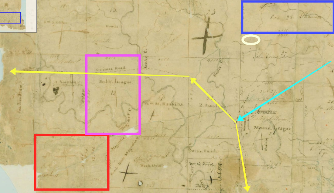
Montgomery's League have been outlined in red. Please note the differences between the red outline of the William Montgomery League
on this map and the red outline of the William Montgomery League on Robin and Joy Montgomery's Map #1. Close Up of 1858 Grimes County Map with Boundary Lines of the William Montgomery League Correctly Outlined in Red Again, you will notice that William Montgomery's League does not
extend across the Grimes County line into Montgomery County as claimed repeatedly on the Montgomery: Naming
Questions webpage. On Robin and Joy Montgomery's Map #1, the red outline incorrectly extends across the Grimes
County line into Montgomery County to include lands that were never owned by William Montgomery. Please notice the names on the lands to the east of the Grimes County line enclosed by
Robin and Joy Montgomery's Map #1 as though the land had been surveyed for, granted to, or owned by William Montgomery:
M. Shannon (Patent Date: August 31, 1844),
Wm. Miller (Patent Date: January 27, 1849),
A. Tinny (Patent Date: February 24, 1847), and
T.C. Bradberry (Patent Date: March 27, 1861). A patent is the legal instrument transferring land from the public domain to private ownership. These
names (M. Shannon, Wm. Miller, A. Tinny and T.C. Bradberry) are the names of the FIRST private owners of these tracts of land. These are the
names of the people who received these tracts of lands from the government of the Republic of Texas or the State of Texas ORIGINALLY. Click the
names above to see the original land grants of each of these individuals in the Texas General Land Office online database. These tracts
of land were NEVER surveyed for William Montgomery! These tracts of land were NEVER granted to William Montgomery! And William Montgomery
NEVER owned these tracts of land! Close Up of Robin and Joy Montgomery's Map #1 Here is a close up of Robin and Joy Montgomery's Map #1 showing the additional tracts of land that Robin
and Joy Montgomery incorrectly claimed were part of William Montgomery's original land grant. It has been enlarged to make
it easier to read the names of the true original land owners (Shannon, Miller, Tinny and Bradberry). In the next section,
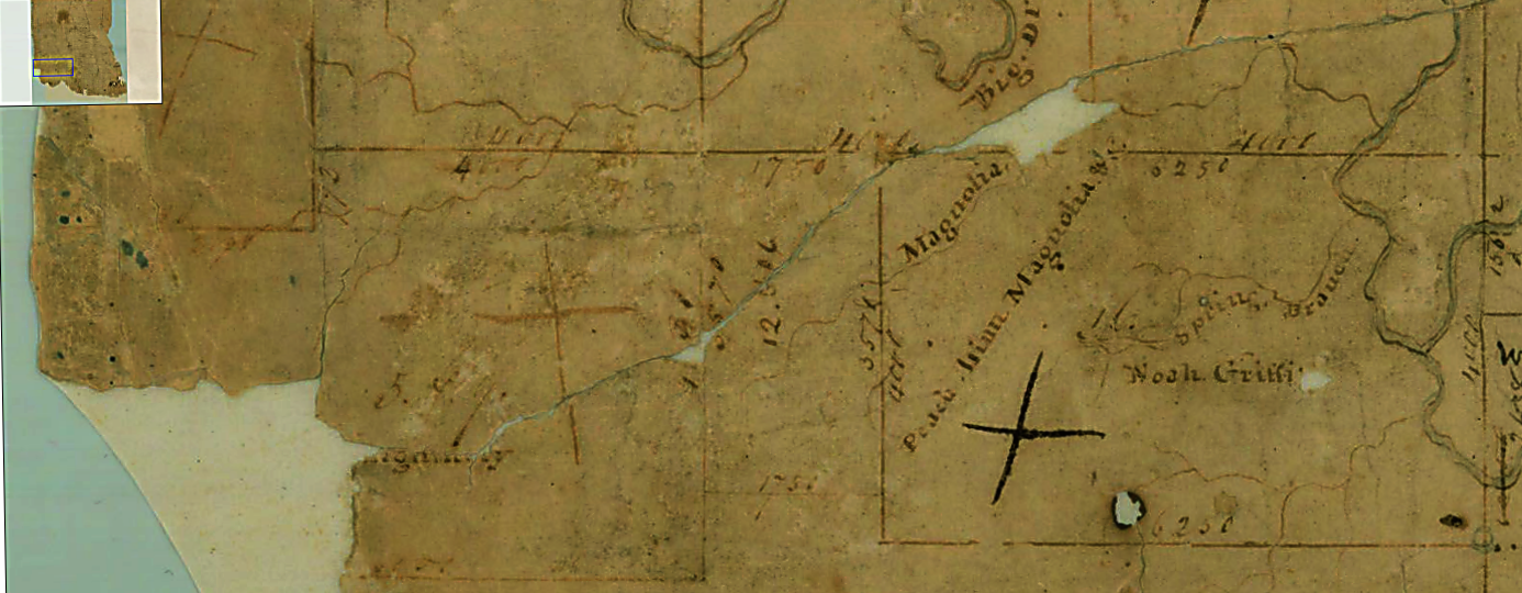
we will look closely at William Montgomery's Mexican land grant and Surveyor E. R. Wightman's field notes and plat. We will
then dispose of this issue permanently. Earliest Primary Sources: William Montgomery's Mexican Land Grant - League No. 5 and 9 and Surveyor Elias R. Wightman's Field Notes and Plat Just in case there are still any doubts in anyone's mind, let's look closely at the two most important
primary sources. These date from the time closest to the events in question themselves. Here is a close up of the Mexican land grant
William Montgomery received from Stephen F. Austin in 1831. In the close-up of William Montgomery's Mexican land grant, we see he
received "Sitio No. 5 y 9" (League No. 5 and 9). More importantly, we see that William Montgomery received League No. 5 and 9 and
nothing else! Land Description from William Montgomery's Mexican Land Grant Showing Sitio No. 5 y 9 Sitio No. 5 y 9 Close Up of William Montgomery's Mexican Land Grant With Sitio No. 5 y 9 Enlarged Happily, you do not have to rely on my translation of the land grant from Spanish to English. Below, are excerpts
from the English translation of William Montgomery's Mexican land grant (William Montgomery League) prepared by Dr. Brian Stauffer the Spanish
Translator of the Texas General Land Office. The translation was prepared for Kameron Searle on September 29, 2020. For the complete translation
of William Montgomery's entire Mexican land grant, just click on either of the English excerpts below and the links will take you
to Dr. Stauffer's translation of the whole document. Excerpt from the English Translation of Page 1 of William Montgomery's Mexican Land Grant (William Montgomery League) Excerpt from the English Translation of Page 3 of William Montgomery's Mexican Land Grant
(William Montgomery League) E. R. Wightman surveyed League No. 5 and 9 which was one league (4,428.4 acres) of land. The
naming of this League is unusual. It is a single league designated by a double number "5 & 9."
Because the John Landrum League had already been designated League No. 5 and the Asa Yeamans League had already been
designated League No. 9, Wightman designated the William Montgomery League as League No. 5 & 9 and that is exactly
how the league is designated in survey field notes and the plat [map] included with the field notes. In the Texas General Land
Office, these field notes are designated
Field Notes 6-418. Click the link to read them. E. R. Wightman wrote a note at the end of his field notes for League No. 5 & 9 and Quarter No. 12 & 16. Wightman
wrote, "N.B. Some of the Leagues and Quarters being laid off subsequent to the numbering of others and consequently out of the [sic] routine I have
substituted a double number such as 5 & 9 ═ 12 & 16 from being adjoining such numbers." [N.B. is the abbreviation for a Latin
phrase meaning "note well." In Modern English, N.B. is used, particularly in legal papers, to draw the attention of the reader to a certain
(side) aspect or detail of the subject being addressed.] At the same time that he surveyed League No. 5 and 9, Wightman also prepared a survey of
Quarter No. 12 and 16 (a quarter of a league is 1,107.1 acres) for Stephen F. Austin.
Quarter No. 12 and 16 was never surveyed for William Montgomery and Quarter No. 12 and 16 was never granted to William Montgomery by
Stephen F. Austin. And Quarter No. 12 and 16 was never owned by William Montgomery. It is very misleading to suggest that Stephen
F. Austin conveyed Quarter No. 12 and 16 to William Montogmery.
As we saw earlier, Stephen F. Austin NEVER granted Quarter No. 12 and 16 to ANYONE. The lands that made up Quarter No. 12 and 16 are
located in present day Montgomery County. The people who originally received these lands, as we saw earlier, were M. Shannon (Patent Date:
August 31, 1844), Wm. Miller (Patent Date: January 27, 1849), A. Tinny (Patent Date: February 24, 1847), and T.C. Bradberry (Patent Date:
March 27, 1861)! So, when Robin and Joy Montgomery drew the boundary of the William Montgomery League to the east beyond the
William Montgomery League on Robin and Joy Montgomery's Map #1, they included more than 1,100 acres of land that were never surveyed for,
granted to, or owned by William Montgomery. It is actually many hundred of acres more as the boundary line on Robin and Joy Montgomery's Map #1
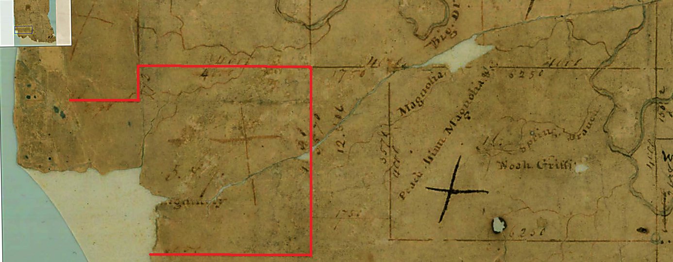
includes several hundred acres south of Quarter 12 and 16 as well. From English Field Notes 6-418: Plat Prepared by Elias R. Wightman Showing League 5 and 9 (William Montgomery League) and Quarter 12 and 16 (Never Granted by Stephen F. Austin to Anyone) Plat Prepared by Elias R. Wightman Showing League 5 and 9 (William Montgomery League) Outlined in Red Plat Prepared by Elias R. Wightman Showing League 5 and 9 (William Montgomery League)
Outlined in Red and Indicating the Other Leagues Granted by Stephen F. Austin Excerpt from the English Translation of Page 3 of William Montgomery's Mexican Land Grant Metes and Bounds of League 5 and 9 (William Montgomery League) Here, again, we have the actual metes and bounds of William Montgomery's Mexican land grant.
Please compare it to the map above with the red outline of William Montgomery's League correctly outlined and see that in 1831
William Montgomery received "League 5 and 9" and not "Quarter 12 and 16." No part of Quarter 12 and 16 is mentioned anywhere in
the description of the metes and bounds of the William Montgomery League. The following is quote
from
History of Texas Public Lands, Appendix II, page 17, a publication of the Texas General Land Office. "Surveying the land
in Mexican Texas followed the metes and bounds system, where natural features of the land (such as trees) are used as landmarks
for the corners, with the distances indicated between them. The surveyors
equipment was a stick called a "Jacob's staff," a compass for determining direction, and a chain for measuring distances.
Each link in the chain was a specified length, making it easier for the surveyor to calculate. Texas surveyors were required
to use the Mexican system of land measurements. The basic unit of linear measurement was the vara, which in Texas came to
equal 33 1/3 inches. The basic unit for measuring area was the sitio or league, equal to 25,000,000 square varas
(4,428.4 acres) and the labor, equal to 1,000,000 square varas (177.1 acres)." William Montgomery's Mexican land grant reads as follows, "it is known as League No. 5 and 9
adjoining and south of John Landrum's and Asa Yeaman's tracts; and from the southeast corner of Yeaman's said league, which
is No. 9, a line was run west with the south boundary of said No. 9 4,000 varas to the east boundary of No. 5; thence south
with said boundary 792 varas to the southeast corner of said No. 5; thence west with the south boundary of said No. 5
belonging to said John Landrum 2,000 varas to a landmark on said boundary; thence south 3,639 varas to a mound of earth;
thence east 6,000 varas to a mound of earth; and thence north 4,431 varas to the place of beginning, comprising within said
boundaries one league of land in area. To claim the lands to the east of William
Montgomery's League were ever granted to William Montgomery is simply false.
William Montgomery had received a league (4,428.4 acres) from Austin and as such
William Montgomery was NOT entitled to any additional land from Stephen F. Austin as a colonist. More Bad Maps and Incorrect Statements We have looked closely at Robin and Joy Montgomery's Map #1 and
the statement that accompanied it which read, "Note the land to the east of William Montgomery's survey was
also part of his original land grant in 1831." By looking at unaltered maps, the Act Creating Grimes County,
William Montgomery's Mexican land grant and E. R. Wightman's English field notes and his plat, we know that
Robin and Joy Montgomery's Map #1 as altered was grossly incorrect and misleading and that the statement
accompanying the map was in fact false. We will now turn our attention to other statements and maps on the webpage Montgomery:
Naming Questions. It will become readily apparent that the other statements and maps accessed
from Montgomery: Naming Questions are just as erroneous as the map and statement
we looked at above. Let's start with another map and the map legend accompanying it. Robin and Joy Montgomery's Map #2 For the sake of discussion, we will refer to the map
above from the Montgomery: Naming Questions webpage as Robin and Joy Montgomery's Map #2. There are other problems with
Robin and Joy Montgomery's Map #2, but we will focus on the William Montgomery League since it is the subject of this webpage. The map
used by Robin and Joy Montgomery to create Robin and Joy Montgomery's Map #2 was Surveys in Austin's Colony along the west bank of
the San Jacinto River by Austin Colony surveyor E. R. Wightman and located in the Texas General Land Office. Click here to
see the original
Surveys in Austin's Colony along the west bank of the San Jacinto River
without the changes made to Robin and Joy Montgomery's Map #2. Underneath Robin and Joy Montgomery's Map #2 is a legend that reads,
"Red: William Montgomery's survey of 1831." Below, we will see the red outline is false. Close Up of Surveys in Austin's Colony along the west bank of
the San Jacinto River Darkened The original map is torn and faded. Using the original scan from the Texas General Land Office,
Searle has zoomed in for a close up and digitally darkened the image so that the lines between the various leagues and between
League 5 and 9 [William Montgomery League] and Quarter 12 and 16 [Never granted by Austin] can be seen more easily. Here is the same map prepared by Searle showing the William Montgomery League correctly outlined in red on
the north, south, and east sides. As we saw above, William Montgomery only received League 5 and 9 and never received Quarter 12 and 16.
On Robin and Joy Montgomery's Map #2, Robin and Joy Montgomery have actually enclosed more than 1,100 acres of land that never belonged
to William Montgomery. Their diagram incorrectly enclosed Quarter 12 and 16 (a quarter league which is 1,107.1 acres of land) plus several
hundred more acres just south of Quarter 12 and 16. • • • Here is another statement from Montgomery: Naming Questions. This statement makes
reference to yours truly, Kameron Searle. Knowing what we do from all of the primary sources above, the reader will
immediately observe that the statement, "Searle focuses on today's Montgomery County but fails
to mention that William Montgomery's land grant of 1831 in Today's Montgomery county." is a completely false statement.
The reason Searle has never mentioned "William Montgomery's land grant of 1831 in Today's Montgomery county" is
that no part of William Montgomery's land grant is located in Montgomery County today! One of the main areas of Kameron Searle's historical research has been the Lake Creek Settlement. After many years
of research, Searle began to present his findings to any and all who would listen. The Lake Creek Settlement had been forgotten. Out of ignorance,
the Lake Creek Settlement and its important role in the early history of Montgomery County had been completely left out of the Montgomery County
history books. To fill the void, guessing and family legends replaced the true history.
To correct the problem, Searle became the most active proponent of the Lake Creek Settlement and tried his best to convince as
many people as he could of the existence of the forgotten Lake Creek Settlement. He did this until the Lake Creek Settlement became
commonly accepted and widely recognized by Montgomery County historians and non-historians alike. Many of the non-historical assertions stated
in Robin Montgomery's 1975 book, The History of Montgomery County were undone and proven to be incorrect by the rediscovery of the
Lake Creek Settlement. These incorrect assertions that had been presented as facts by Robin Montgomery in The History of Montgomery County
were shown for what they actually were: incorrect guesses by the author or the erroneous details of a Montgomery family fable believed by
the author and repeated to his readers. Examples of these non-historical assertions included the so-called Andrew Montgomery Trading Post for which
no primary source evidence has ever been found to prove its existence. Another claim was the alleged existence of a road or trace called the
the Loma del Toro. No such road by that name
ever existed in the area that became Montgomery County. Yet another example of an incorrect assertion is the Upper Coushatti Trace. This is
yet another road that did not exist and for which there is no primary source evidence. There was also no road or trace known as the Lower Coushatti
Trace as alleged in The History of Montgomery County. On the map in The History of Montgomery County,
the actual Coushatti Trace is drawn in the wrong place and shown heading in the wrong direction. Robin Montgomery must have claimed a dozen times
or so that the area
around the Andrew Montgomery Trading Post [which did not exist] and where the town of Montgomery would later be founded had been known as
Montgomery Settlement or Montgomery Prairie. But as the world has now learned, the area in which the town of Montgomery was founded was actually
known as the Lake Creek Settlement prior to the founding of the town. Searle’s research into the Lake Creek Settlement put an end to all the nonhistorical assertions that the
area where the town of Montgomery was founded had once been known as Montgomery, Andrew Montgomery's Trading Post, Montgomery
Settlement, or Montgomery Prairie prior to the founding of the town of Montgomery. As historian David Hackett Fischer has stressed the burden of proof for any historical assertion rests on
the historian making the assertion and not his readers. Robin Montgomery shirks this responsibility regularly leaving it to others to point
out his non-historical mistatements and incorrect assertions.
My article,
Andrew Montgomery Never Received a Land Grant From Stephen F. Austin, and its companion
article
Montgomery Brothers Were Latecomers, and this webpage, William Montgomery Land Grant Not Located in Montgomery County
are three more examples of this. It would seem his strategy is to make an assertion, and if no one challenges it, it must be true.
If this is his strategy, it is nothing more than a political trick (such as spin and fake news) and has no place in
scholarly historical writing. Lake Creek Settlement Marker Dedicated on February 25, 2017 in front of the Nathaniel Hart Davis Museum and Pioneer Complex in Montgomery, Texas In 1837, the town of Montgomery was founded in the middle of the Lake Creek Settlement on 200 acres of land owned by
W. W. Shepperd and located on the John Corner League. William Montgomery did not live in the Lake Creek Settlement and neither did
his sons, Andrew, Edley and John. The false assertion that William Montgomery's survey/land grant/league is somehow located in Montgomery
County today appears to be a rather desperate attempt to place William Montgomery closer to the Lake Creek Settlement and the
location where the town of Montgomery was actually founded. • • • From the webpage Montgomery: Naming Questions, we find another map by Robin and Joy Montgomery that we will call
Robin and Joy Montgomery's Map #3. This map is preceded by two statements which are included here as they appeared on
September 9, 2020. Robin and Joy Montgomery's Map #3 Knowing what we do from all of the primary sources above, the reader will
immediately observe that the statement, "As it turns out- William's survey extended into today's Montgomery County
in 1831, (See below)" along with the map accompanying the statement are again completely false. See the evidence we looked
at in the primary sources above (1858 Map of Grimes County, the Act Creating Grimes County, William Montgomery's Mexican land
grant, and E. R. Wightman' field notes with plat). The statement, "William Montgomery's survey in present Montgomery County," is also false. If you have stayed with
me so far, you will immediately see the problems with Robin and Joy Montgomery's Map #3.
As in Robin and Joy Montgomery's Map #1 and Robin and Joy Montgomery's Map #2, the boundary line of the William Montgomery League is incorrectly drawn.
It is even sloppier here. The supposed boundary line of the William Montgomery League has been drawn with a thick orange line by Robin and Joy
Montgomery up into part of the Asa Yeamans League and over into the John Landrum League again. The orange boundary line is incorrectly
drawn to the east of the William Montgomery League so as to include all of Quarter 12 and 16, the land just south of Quarter 12 and 16,
part of the Noah Griffith League and part of the Jacob Shannon League. Since Quarter 12 and 16 was never granted to William Montgomery,
Robin and Joy Montgomery's Map #3 is incorrectly drawn in the same manner as Robin and Joy Montgomery's Map #1 and
Robin and Joy Montgomery's Map #2. There is is also a problem with the Grimes County line as drawn on Robin and Joy Montgomery's Map #3. It is shown with
a light blue line/arrow running due north and south. We all know, having looked at the 1858 Grimes County map earlier, that the Grimes County line runs
from the northeast corner of the William Montgomery League at an angle towards the southwest corner of Walker County. The blue line/arrow on
Robin and Joy Montgomery's Map #3 appears to run due north and south and does not follow the true direction of the Grimes County line.
See the 1858 Grimes County Map and "An Act Creating Grimes County" above. In the map prepared by Searle above, the boundary line of the William Montgomery League has been
corrected using a thin red line to distinguish it from the thick orange line used by Robin and Joy Montgomery. Nothing outside the thin red
boundary line ever belonged to William Montgomery. And, of course, no part of the William Montgomery League extends into present
day Montgomery County. Last is a map prepared by Searle showing the correct angle of the Grimes County line (dark blue arrow) as it moves
from the northeast corner of the William Montgomery League up towards the southwest corner of Walker County. See the 1858 Grimes County Map
and "An Act Creating Grimes County" above for a better understanding of this angle. • • • There are more statements on the Montgomery: Naming Questions webpage claiming William Montgomery's League is
somehow located in Montgomery County today. Here are two more examples of statements accessed on September 9, 2020. If you have stayed
this far, you can immediately see for yourself that both of the statements below are false. Both of these statements are, of course, false. There may be more such statements, assertions and maps on
the Montgomery: Naming Questions webpage; but you get the picture, and we do not need to analyze additional examples at
this point. So let's move along. Just the Place for a Snark! > Throughout the webpage, Montgomery: Naming Questions, assertions are made to the effect that William
Montgomery's League is somehow located within the boundaries of today's Montgomery County. This is just so much nonsense. Here are the
six examples previously discussed in the sections above. As concerns the William Montgomery League, none of these statements are true. These
are examples of a historical fallacy that Pulitzer Prize winning historian David Hackett Fischer refers to on page 302 of his book
Historians'
Fallacies: Towards a Logic of Historical Thought (New York: Harper and Row, 1970) as an argument ad nauseam. Fischer describes argument ad nauseam as "a serious error, in which a thesis is sustained by repetition
rather than by reasoned proof. This strategy was a favorite of Lewis Carroll's immortal Bellman in The Hunting
of the Snark." "Just the place for a Snark!" the Bellman cried As he landed his crew with care; Supporting each man on the top of the tide By a finger entwined in his hair. "Just the place for a Snark!" I have said it twice: That alone should encourage the crew. "Just the place for a Snark!" I have said it thrice: What I tell you three times is true." The Complete Works of Lewis Carroll, p.757 William Montgomery received a league of land from Stephen F. Austin in 1831 which is located entirely in Grimes
County today. No part of the William Montgomery League is located in Montgomery County today. To say that part of the William Montgomery
League is located in Montgomery County today is obviously not true. And such statements never will be true no
matter how often they are repeated! Argumentum ad nauseam (argument to the point of disgust; i.e., by repetition): This is the fallacy of trying to prove something by saying it again and again. But no matter how many times you repeat something, it will not become any more or less true than it was in the first place. Of course, it is not a fallacy to state the truth again and again; what is fallacious is to expect the repetition alone to substitute for real arguments. Logical Fallacies and the Art of Debate - CSUN.edu CSUN.edu (California State University, Northridge) The real danger is not that a scholar will delude his readers, but that he will delude himself. Historians' Fallacies: Toward a Logic of Historical Thought David Hackett Fischer (Harper and Row: New York, 1970), p. 63 "It ain't what you don't know that gets you into trouble. It's what you know for sure that just ain't so." Attributed to Mark Twain
"Juuuusst a bit outside. He tried the corner and missed." Harry Doyle (Bob Uecker) Major League (1989) In one of my articles
[in the Montgomery County News newspaper], I
had mentioned that William Harley Gandy had interviewed J. L. Montgomery of Richards, Texas while writing his
master’s thesis in 1952. I had questioned the fact that Robin Montgomery’s grandfather J. L. Montgomery made
no mention of an Andrew Montgomery trading post in his interview with Gandy. In this 1952 interview, J. L.
Montgomery had advised William Harley Gandy that Montgomery County was named after a surveyor named William
Montgomery. In his 1952 master’s
thesis, Gandy wrote, “Another local story has it that Montgomery took its name from William Montgomery, a
surveyor and widower, who came to Texas in 1822 with his sons…. In 1830, he settled some seven miles southwest
of the town of Montgomery in what is present day Grimes County…. It is claimed by the descendants of these two
brothers [John and Andrew] that the county was named for the surveyor William Montgomery.” In 1975, after 152 years of silence, from the alleged date it was founded, the Andrew
Montgomery Trading post sprang forth in Robin Montgomery’s book, The
History of Montgomery County (Austin: Jenkins Publishing Co., 1975) complete in every detail for the very
first time anywhere. On page 285 of The History of Montgomery County, Robin Montgomery wrote, “This
book has shown that the reason the town and county came to be named for Andrew Montgomery lies in the events
surrounding his trading post.” Robin goes on to write, “Andrew
immediately set about encouraging settlers to venture down these roads to become his neighbors and clientele.
In this manner Andrew’s Trading Post became the major pivot point around which the settlement of the later
Montgomery County region revolved. Andrew’s last name became a unifying element among the gradually expanding
circle of settlement.” In my article, I had asked why
J. L. Montgomery, nor any other member of the William Montgomery family, had ever made any mention of this
Andrew Montgomery Trading Post before 1975. If the trading post was established in 1823, how is it that no
one ever mentioned it for 152 years until 1975? In his May 20, 2009 letter to the
editor, Robin attempts to address this question and provides a most extraordinary answer with ramifications that
would seem to completely undo Robin’s history of the Andrew Montgomery Trading Post. I do not believe I could
have written a more critical or damaging statement regarding this portion of Robin’s history than he himself has
written. My contention is that a couple of Robin's comments in his letter to the editor
completely undo his history of the Andrew Montgomery Trading Post and reveal it for what it is: family
fiction rather than family tradition. Robin's grandfather, J. L. Montgomery, clearly knew nothing about
an Andrew Montgomery Trading Post when Gandy interviewed him in 1952. It is Robin's response to this
point in his letter to the editor that wreck's his history. Please read this very carefully. In his May 20, 2009 letter to the editor, Robin
wrote: “…the William-Andrew Montgomery descendants did
not know of the Shannon tradition until the Historicade in Conroe in 1949. When actors in that ceremony stated
that the town was begun by a Montgomery Trading Post operated by the Shannon’s, as a child I heard the elder
members of my family exclaim, “They have forgotten William and Andrew!”” “Hence the family pieced together the logical
sequence that, if Shannon tradition ran true, the Shannon’s assumed a facsimile of the business which Andrew, by
then into surveying, had pioneered years earlier, and given that Owen Shannon’s wife’s maiden name was
Montgomery, continued the name.” “Also during the early fifties, from an elderly
relative the family received a book of notes since referred to as the Crittendon papers. It included an excerpt from the family Bible reinforcing oral tradition:
“Andrew rode with Dr. Long [Long Expedition 1819-1820] Started Montgomery Settlement.” Accordingly, during this
period of reassessment the Montgomery family began to consider Andrew rather than the patriarch, William as the
probable basis for the naming of the town.” Fascinating! J. L. Montgomery had the opportunity to set the record straight in his
interview with William Harley Gandy in 1952. But, as upset as
the Montgomery Family allegedly was following the 1949 Historicade, J. L. Montgomery made no mention to Gandy
of any trading post operated by the Montgomery family in the 1820’s. Robin then admits
that the Montgomery “family pieced together the logical sequence that if Shannon tradition was true, the
Shannon’s assumed a facsimile of the business which Andrew…had pioneered years earlier…” Robin amazingly admits the Montgomery family incorporated the Shannon
family tradition of a Montgomery Trading Post directly into the Montgomery family tradition. No fact checking
was done. It just says, “that, if Shannon tradition ran true.” Whether it was true or not, Robin informs
us that the Montgomery family incorporated the Shannon tradition into their own family tradition.
Though unchecked, the Shannon's Montgomery Trading Post story was obviously a very popular idea, so the
Montgomerys just included it into their story. Robin then mentions an excerpt from “the family Bible.” He wrote that the Crittendon
papers “included an excerpt from the family Bible reinforcing oral tradition: “Andrew rode with Dr. Long
[Long Expedition 1819-1820] Started Montgomery Settlement.”” We are left with a great many questions about this “excerpt from the family Bible” and
the Crittendon papers. Why is this excerpt not mentioned in Robin’s 1975 book or any book or article written
by Robin since 1975. Why is this excerpt coming to light for the
first time in May of 2009. Whose family bible was this? Who
wrote the note? Whose handwriting is the note in? What is the
provenance of this family Bible? Why has no one been allowed to
see this excerpt or the Crittendon papers since 1975? Is there anything about the excerpt that tells us where
the “Montgomery Settlement” was supposed to have been? Will Robin Montgomery allow us to see the Crittendon
papers or this excerpt in order to judge their historical value? Then Robin writes the most extraordinary statement of all: “Accordingly, during this period of reassessment the Montgomery family began to
consider Andrew rather than the patriarch, William as the probable basis for the naming of the
town.” The Montgomery family
changed their story altogether “during this period of reassessment” in the 1950’s! “During this period of reassessment,” they reject J. L. Montgomery’s family
history that says the surveyor William Montgomery is the source of the name of the county and they “began to
consider Andrew…as the probable basis for the naming of the town.”
Not only did the Montgomery family change the story, but they also guessed! After about 125 years, the
Montgomery family threw out the family tradition of William Montgomery as the source of the county's name after
watching a play in 1949 and receiving the mysterious and unproven "Crittendon papers." The
Montgomery family arbitrarily changed, in the 1950's, what had allegedly been handed down in the
Montgomery family from one generation to the next for 125 years. Up until 1952, the
Montgomery family tradition, of which we have a snap shot from Gandy’s thesis, was that the source of the name
of the county was the surveyor William Montgomery, not a trading post. After 1952, the Montgomery family rejects
their family tradition received from Robin’s grandfather, J. L. Montgomery. They incorporate much of the Shannon family tradition regarding a so-called
Montgomery Trading Post that was not present in the 1952 interview, and then they guess that Andrew must have
been the probable basis of the naming of the town. Wow! Knowing now what Robin has told us, is anybody still on board with the Andrew
Montgomery Trading Post at this point? It is not what someone else or I have written or speculated. This is clearly what
Robin Montgomery has written himself. Robin’s quote is out there for all to consider and critique
forever. As I stated earlier, I believe Robin has completely undone the main historical premise of
his entire book. The Montgomery family can't just decide to
completely rework their family tradition into something brand new during the 1950's and then insist that it
is a valid historical source or oral family tradition dating from the 1820's. It has been difficult for historians to respond to Robin’s history of an Andrew
Montgomery Trading Post as he makes so many dogmatic assertions rather than reasonable and defensible
arguments. Famed historian, David Hackett Fischer, made it very clear in his classic book
Historians' Fallacies that "the burden of proof, for any historical assertion, always rests upon its
author." See Historians' Fallacies: Toward
a Logic of Historical Thought (New York: HarperCollins, 1970), pp. 62 and 63. Robin cites no primary sources of evidence in
his 1975 book for his history of an Andrew Montgomery Trading Post. Only now does he tell us fragments
of alleged evidence which he has not previously cited or shown to anyone before. Robin violates two more of David Hackett Fischer's rules of thumb for writing
history. Fischer wrote, "An historian must not merely provide good relevant evidence but the
best relevant evidence. And the best relevant evidence, all things being equal, is evidence which is
most immediate to the event itself." Rather than primary historical sources dating from
the time of the event itself, Robin's evidence is a reworked family history or tradition that actually only
dates in its current form from the 1950's. Fischer also
wrote, "An empirical statement must not be more precise than its evidence
warrants." Look at Robin's 1975 book. See what he wrote
about the trading post. It was extremely precise. In 1975, his dogmatic assertions regarding an
Andrew Montgomery Trading Post were presented as absolute facts. Robin is now trying to convert his
dogmatic assertions from his 1975 book into defensible arguments. With no real primary historical
evidence of any kind to back him up, he has an impossible task ahead of him. Kameron Searle,
J.D.
This article originally appeared in the June 3, 2009 edition of the Montgomery County
News. "A history, whose author draws conclusions from other than primary sources
or secondary sources actually based on primary sources, is by definition fiction and not history at all." Kameron K. Searle
Andrew Montgomery - TSHA Handbook of Texas Lake Creek
Settlement- TSHA Handbook of Texas Kameron Searle 9111 Katy Fwy., Suite 202 Houston, Texas 77024 Telephone: 713-880-4529 |