Elias R. Wightman - English Field Notes,Plats and Mapsby: Kameron Searle Information about the surveys and English field notes prepared by Elias R. Wightman in 1831 in what is today western Montgomery County, Texas. Web page provides details including the roads and traces then in existence in 1831 in that part of Texas. The links are to pdf files of actual scans of the field notes and plats prepared by E. R. Wightman in Austin's Second Colony between the West Fork of the San Jacinto River and Lake Creek. This page is for historians and students of Montgomery County, Texas history to use as a historical research resource. Wilie Smith [Wiley B. D. Smith] Quarter League
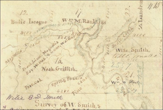
http://https://s3.glo.texas.gov/ncu/SCANDOCS/archives_webfiles/arcmaps/webfiles/efns/6-415.pdf Wiley B. Smith - Texas General Land Office English Field Note 6-415. These Field Notes include a plat/map of several different land grants in what would become the Lake Creek Settlement. Leagues and other land grants shown on this map include: the Bedie League, the Wm. M. Rankin League, the Zachariah Landrum League, the Wilie Smith quarter league, the Noah Griffith League, and the Iron Mound League. Lake Creek and Bedie Creek are shown running through some of these land grants. The surveyor shown in the notes was E. R. Wightman and the chain carriers were James Rankin and William Rankin. No roads or traces are shown on this particular plat. Nice map though the field notes are little blurry. |